School Detection in Sudan: Satellite Imagery and Object Detection for Internet Connectivity Planning
12 min readUpdated August 27, 2026
Omdena
Sudan’s school location records are incomplete, inaccurate, or absent across large portions of the country — a critical barrier to Giga’s mission of connecting every school to the internet. Omdena partnered with Giga (the joint UNICEF and ITU initiative) and UNICEF’s Sudan Country Office to build a deep learning model identifying school locations from high-resolution satellite imagery. Fifty-two engineers over six weeks delivered a school detection model achieving 95% accuracy in identifying school locations and boundaries across Sudan.
KEY OUTCOMES
Timeline
Six-week collaborative AI challenge
Team
52 global collaborators
Detection accuracy
95% accuracy in school location identification and boundary delineation
Data input
Geo-diverse high-resolution satellite imagery of Sudan + school coordinates from UNICEF Sudan Country Office
Deliverable
Validated deep learning school detection model, published as open source
Platform
School locations designed for integration with Giga’s Project Connect — the real-time school connectivity map
Partners
Giga (UNICEF + ITU), UNICEF Sudan Country Office, Omdena
The Problem: Sudan’s School Data Gap and the Global Digital Divide
Sudan’s education system faces challenges that are both structural and contextual. Many children in Sudan are not in school, and for those who are, connectivity levels remain very low, limiting access to online learning materials and digital tools. Accurate, up-to-date school location data is the foundation for addressing either problem: you cannot connect a school you cannot find.
Giga’s Project Connect platform maintains a real-time map of school connectivity across 35 countries, tracking which schools have internet access and which do not. Over 900,000 schools have been mapped and are viewable live. But the platform depends on accurate school location data — and in Sudan, that data was largely missing, incomplete, or outdated in existing records.
Without knowing where schools are, it is not possible to assess their connectivity status, plan infrastructure, or direct resources to where they are needed. Mapping school locations is the precondition for everything that follows — connectivity investment decisions, government resource allocation, and progress tracking toward the goal of giving every child access to online learning.
The Partnership: Omdena, Giga, UNICEF, and ITU
Giga is a joint initiative of UNICEF and the International Telecommunication Union (ITU), created to connect every school to the internet. Its Project Connect platform provides real-time school connectivity data to governments, donors, and infrastructure planners. The Sudan school mapping project was designed to fill a critical gap in Giga’s data coverage.
UNICEF’s Sudan Country Office played a central role in the project. With a presence on the ground and a deep understanding of the local context, the Country Office provided the AI mapping team with the contextual parameters needed to distinguish schools from other types of buildings in Sudanese satellite imagery — an input that was critical to the model’s accuracy.
Omdena contributed its collaborative challenge model and OmdenaLore — a community-driven open-source AI library built by more than 200 certified collaborators, with a codebase exceeding 30,000 lines of code. All code developed during the project was published as open source, making the approach available for replication in other countries facing similar school location data gaps.
Why Traditional Mapping Failed: Remote Areas, Conflict, and Missing Records
Traditional school mapping methods rely on field visits: surveyors travel to locations, confirm school presence, and record coordinates. In Sudan, this approach runs into multiple barriers. Many schools are in remote or geographically isolated areas where travel is difficult; others are in regions affected by conflict or insecurity, making field visits dangerous or impossible to conduct systematically.
Even where field visits are feasible, they are expensive and slow, unsuitable for the scale of coverage Giga requires. Satellite imagery offered a different path: consistent coverage across the country, regardless of ground accessibility, at a fraction of the cost. The challenge was making that imagery machine-readable — teaching an AI to distinguish a school building from a warehouse, a mosque, or a home.
Building the School Detection System: Satellite Imagery, Deep Learning, and Local Expert Input
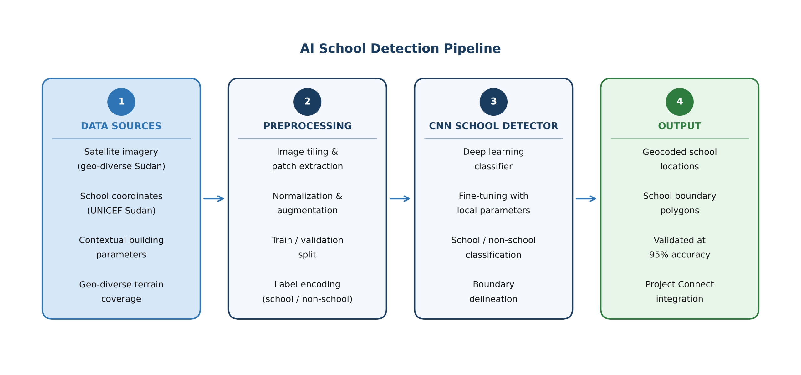
The four-stage AI pipeline: satellite imagery and expert-supplied ground truth, image preprocessing, CNN school detection with local calibration, and geocoded output integrated into Giga’s Project Connect. Image source: Omdena
Data Collection and Preprocessing
The team worked with geo-diverse, high-resolution satellite images of Sudan, selected to represent the range of geographic environments and building types across the country. A limited set of school location data points was provided by UNICEF’s Sudan Country Office — known school coordinates that served as the ground truth anchor for training and validation.
Imagery was deliberately sourced from across Sudan’s varied terrain types, including desert, savannah, peri-urban, and dense urban areas, to prevent the model from overfitting to a single environment. Source images were tiled into fixed-resolution patches to standardize inputs and generate sufficient training volume from a limited set of source scenes. Augmentation techniques including rotation, flipping, and brightness variation further expanded the training set and improved robustness to variation in ground conditions and satellite capture angle.
Model Development
Deep learning algorithms were trained to classify satellite image patches as school or non-school, based on visual characteristics including roof shape, building footprint, compound layout, and surrounding context. The challenge was that schools in Sudan can closely resemble other institutional buildings when viewed from above, requiring the model to learn subtle distinguishing features rather than obvious visual signatures.
Deep learning was chosen over traditional rule-based image analysis because convolutional neural networks learn visual features directly from data rather than relying on hand-crafted detection rules. This matters in the Sudanese context because school buildings can closely resemble warehouses, mosques, or residential compounds when viewed from orbit. Only a model trained to recognize compound-level spatial patterns handles this ambiguity reliably at scale.
Local Expert Calibration
UNICEF’s Sudan Country Office provided contextual parameters specifying the architectural and spatial patterns that characterize school compounds in the Sudanese context. These parameters were used to fine-tune the model, anchoring its detection criteria to the actual building types and layouts it would encounter in the field. This local calibration was a critical differentiator from models trained on data from other countries.
Models pre-trained on school imagery from other countries do not transfer reliably because building layouts, roof materials, and surrounding land use differ significantly by geography. Fine-tuning the classifier with UNICEF Sudan’s context-specific parameters anchored detection criteria to the actual visual patterns present in Sudan rather than patterns learned from environments with different structural and spatial characteristics.
Training and Validation
The model’s performance was validated against the known school locations provided by UNICEF’s Sudan Country Office. The system achieved 95% accuracy in identifying school locations and delineating school boundaries, a strong result for this type of computer vision task in an environment where labelled ground truth data was limited. The validation process confirmed the model’s ability to generalize across the full range of terrain types represented in the geo-diverse training set.
What Was Delivered: A Validated Deep Learning School Detection Model
The project delivered a deep learning school detection model validated at 95% accuracy — a benchmark figure for this type of satellite-based classification task. The model identifies school building locations from high-resolution imagery and delineates their boundaries, producing geocoded school location data that can be ingested directly into connectivity planning systems.
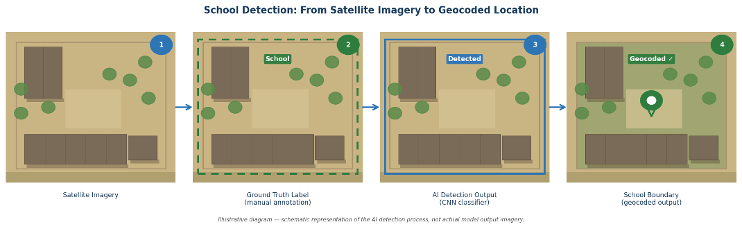
Illustrative overview of the school detection process: raw satellite imagery patch (1), manual ground truth annotation (2), CNN classifier output (3), and final geocoded school boundary (4). Image source: omdena.
New school locations identified by the model were designed for integration with Giga’s Project Connect platform, expanding coverage in Sudan beyond what was previously mapped. The Project Connect map shows all known schools as data points, giving governments and infrastructure providers a picture of where schools exist, and whether they are connected once further data is gathered.
The full model codebase was published as open source through OmdenaLore. Countries with similar school location data gaps can adapt and apply the same approach — provided they have access to high-resolution satellite imagery and local contextual knowledge for calibration. The Sudan project established a reusable template for AI-based school mapping in low-data environments.
Impact: From Unmapped to Actionable — What the Model Changed
The project’s core demonstrated outcome is a school detection model validated at 95% accuracy against known school coordinates across geo-diverse Sudanese terrain. Schools in Sudan include unroofed compounds, temporary structures, and buildings shared with other institutional functions, making them among the harder cases for satellite-based classification. Reaching 95% in this environment establishes that machine-based school mapping is operationally viable in Sudan.
The model’s integration pathway into Giga’s Project Connect platform converts each AI-identified school location into a data point on the real-time connectivity map used by governments and infrastructure planners across 35 countries. Sudan’s coverage on that map was constrained by incomplete and missing location records before this project. The school detection model addresses that gap directly, producing geocoded locations and boundary polygons at a precision level that supports infrastructure planning decisions.
What the data enables is more consequential than the model itself. Governments and donors using Project Connect can assess which schools in Sudan are connected, which are reachable for infrastructure investment, and where the connectivity gap is largest. Network rollout decisions that previously had to rely on incomplete or outdated records can be grounded in AI-generated, satellite-validated location data that reflects where schools actually are.
Benefits for Clients: What Giga and UNICEF Gained
The primary clients for this project were Giga and UNICEF’s Sudan Country Office. What they received went beyond the 95% accuracy result.
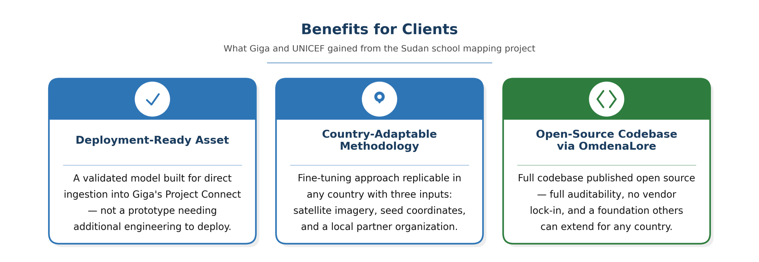
Three client benefits from the Sudan school mapping project: a deployment-ready detection model, a country-adaptable methodology, and an open-source codebase via OmdenaLore.
A Deployment-Ready Asset, Not a Prototype
The school detection model was built and validated with Project Connect data ingestion as a design constraint from the start. The geocoded school locations and boundary polygons produced by the model are structured for direct ingestion into Giga’s mapping infrastructure, not further processing. This distinction matters: the project delivered a usable asset with a clear integration pathway, not a research output requiring additional engineering before it can be deployed.
A Country-Adaptable Mapping Methodology
The technical approach of fine-tuning a base model using local expert parameters is systematically replicable. Each new country Giga targets for school mapping requires the same three inputs: high-resolution satellite imagery, a seed set of known school coordinates for ground truth, and contextual building parameters from a local partner organization. This framework significantly lowers the engineering cost and timeline for each subsequent mapping effort, turning a one-country project into a scalable methodology.
Open-Source Codebase Through OmdenaLore
The full model codebase was published as open source through OmdenaLore, giving Giga and its partners full auditability of the methodology, freedom from vendor lock-in, and a foundation that others can extend and improve. Countries and NGOs facing the same school location data challenge can adapt the codebase independently rather than commissioning a new build from scratch. For Giga specifically, the open-source release supports its broader goal of making school connectivity data a freely accessible public resource.
What Building an AI School Detection System for a Conflict-Affected Country Taught Us
Satellite mapping is viable without comprehensive ground truth — but local calibration determines accuracy
The project worked with a limited set of known school coordinates from UNICEF’s Sudan Country Office. That constraint shaped the approach: rather than a fully supervised training regime requiring thousands of labelled examples, the model was calibrated using contextual parameters from local experts. The result showed that a constrained but well-targeted ground truth can support high-accuracy detection.
School buildings look different from orbit in different countries — models require country-specific adaptation
A deep learning model trained on school images from one country does not transfer reliably to another. Building layouts, roof materials, compound configurations, and surrounding land use differ significantly between contexts. The fine-tuning process with UNICEF Sudan Country Office parameters addressed this directly, and the open-source release ensures future implementations can apply the same adaptation process for their own contexts.
Open-source release turns a single-country project into a global tool
By publishing the codebase through OmdenaLore, the Sudan project became a reference implementation for AI-based school mapping. Organisations facing the same challenge in other countries — particularly in sub-Saharan Africa, South Asia, or other regions where school location data is incomplete — can adapt the approach rather than starting from scratch. Open-source release extends impact beyond the immediate project scope.
What’s Next: Scaling the Model Across Sudan
The immediate next step is scaling the model across the entirety of Sudan. The pilot covered a geo-diverse subset of the country; the next phase applies the same model to the full national territory, with the aim of uncovering school locations that are entirely absent from current records.
The data generated by full-country mapping will support the Sudanese government in knowing precisely where schools are located, what infrastructure investment is required, and where connectivity already exists but may be unreliable. This information feeds directly into Giga’s core mission: building the evidence base for targeted, cost-effective school connectivity across the country.
Key Achievements
Deep Learning School Detection Model
A computer vision model trained on high-resolution satellite imagery of Sudan, achieving 95% accuracy in identifying school building locations and delineating school boundaries. Validated against known school coordinates provided by UNICEF’s Sudan Country Office.
Expanded School Coverage on Project Connect
School locations identified by the model were designed for integration with Giga’s Project Connect platform, extending coverage in Sudan for the real-time school connectivity map used by governments and infrastructure planners across 35 countries.
Open-Source School Mapping Codebase via OmdenaLore
The full model codebase, developed by 52 engineers across a six-week challenge, was published as open source through OmdenaLore — making the approach replicable for other countries facing incomplete school location data.
About the Project
This case study describes a six-week AI collaborative challenge between Omdena, Giga (the joint UNICEF and ITU initiative), and UNICEF’s Sudan Country Office. The project developed a deep learning model to identify school locations from high-resolution satellite imagery of Sudan, achieving 95% accuracy in school detection and boundary delineation. The full codebase was published as open source through OmdenaLore.
FAQ
What is Giga and why does school location data matter to its mission?
Giga is a joint initiative of UNICEF and the International Telecommunication Union (ITU), created to connect every school to the internet. Its Project Connect platform maps school connectivity in real time across 35 countries. To determine whether a school is connected, the platform first needs to know the school exists — which requires accurate location data. In Sudan, that data was largely missing.
How does the AI model identify schools in satellite imagery?
The model was trained to classify image patches from satellite imagery as school or non-school, based on visual characteristics including roof shape, building footprint, compound layout, and surrounding land use. It was fine-tuned using contextual parameters from UNICEF's Sudan Country Office, which provided specific architectural and spatial patterns that distinguish school compounds in the Sudanese context.
What data was used to train the model?
The training dataset consisted of geo-diverse, high-resolution satellite images of Sudan and a set of known school location coordinates provided by UNICEF's Sudan Country Office. The ground truth data was limited, a common constraint in countries where school records are incomplete. The model was designed to work effectively within this constraint rather than requiring a large labelled dataset.
Is the model currently in active use?
The model and school location data produced during the project were designed for integration with Giga's Project Connect platform. The next phase — scaling the model to cover the full territory of Sudan — was planned at the project's conclusion. Active monitoring of connectivity at the newly mapped schools depends on subsequent field validation and infrastructure data collection by Giga and the Sudanese government.
Can this approach be applied to other countries?
The approach was designed with replication in mind. The model architecture and training pipeline are published as open source through OmdenaLore. Applying the model to a new country requires high-resolution satellite imagery, a seed set of known school coordinates for calibration, and contextual parameters from a partner with on-the-ground knowledge: the same inputs Giga and UNICEF's Sudan Country Office provided.
Share this article
Share on LinkedIn, send by email, or copy the direct link.