AI for Disaster Response: Predicting Cyclone Impact and Aid Needs Before Field Teams Arrive
10 min readUpdated September 18, 2026
Omdena
Population impact estimates are unavailable in the critical hours after cyclone landfall, when relief logistics cannot wait for field assessments. Omdena partnered with the WFP Innovation Accelerator to build a machine learning system that converts cyclone forecasts into population estimates and itemized relief plans. The project delivered an XGBoost prediction model and an offline relief calculator in 8 weeks, both open source and field-ready.
Watch the Webinar
See how AI can help humanitarian teams anticipate disaster impacts and plan faster, more targeted relief.
In this webinar, we explore the approach, data, and AI technologies behind the project, along with key findings and practical applications for earlier disaster response and relief planning.
Key Outcomes
Outcome
Detail
Data integrated
5 datasets covering historical cyclone events across multiple basins, meteorological and socioeconomic features
Streamlit web app + offline Python GUI for low-bandwidth field use
Planning time
Reduced from hours to minutes in many cases for end-to-end relief package estimation
Extensibility
Architecture designed for cyclones; applicable to earthquakes, floods, and tsunamis
The Problem: Estimating Relief Needs Before the Roads Open
When a cyclone makes landfall, humanitarian agencies face a contradiction. The window for pre-positioning supplies is narrow: decisions must be made within hours. Yet those same hours are when communications networks go down, roads flood, and firsthand assessments become impossible. Relief operations launched on poor estimates either reach the wrong locations or arrive with the wrong goods.
The World Food Programme assists close to 100 million people annually across 83 countries. Traditional needs assessments rely on expert judgment and field reports, a process that can take days when cyclones destroy roads and communications. This project asked a direct question: can machine learning produce defensible estimates fast enough to matter?
The Partnership: Omdena and the WFP Innovation Accelerator
Omdena partnered with the WFP Innovation Accelerator to build a proof-of-concept disaster estimation system. A team of 34 data scientists and humanitarian specialists across 19 countries spent 8 weeks mapping WFP’s operational reality: how assessments are conducted, how packages are calibrated to nutritional standards, and what field deployment conditions any tool must handle.
Why Disaster Impact Estimation Is Hard
Fragmented, inconsistently formatted data: Humanitarian and meteorological data are distributed across dozens of sources, often stored in scanned reports or non-standard formats. More than 70% of the project’s time was spent locating, digitizing, cleaning, and integrating data before any modeling could begin.
Impact varies enormously by socioeconomic context: A cyclone of identical wind speed causes dramatically different casualties and displacement depending on local GDP, rural population share, housing quality, and access to services. No single meteorological variable predicts impact reliably without this context.
Large catastrophic events are underrepresented in historical records: Models trained on historical data perform well for moderate-scale events (up to roughly 150,000 affected) but struggle with rare, extreme events where fewer training examples exist. The team documented this performance range explicitly rather than overfitting to catastrophic cases, making the accuracy profile transparent for operational use.
Field deployment must function without reliable connectivity: A tool that requires a stable internet connection is not useful in the immediate aftermath of a cyclone. Any deployable solution had to work in low-bandwidth or fully offline conditions, which constrained the architecture from the outset.
Building the Cyclone Impact Estimation System: ML Modeling and Relief Calculation
The build was divided into two linked pipelines: a machine learning model to estimate affected populations, and a mathematical tool to translate those estimates into itemized relief requirements. Both had to be deployable in field conditions.
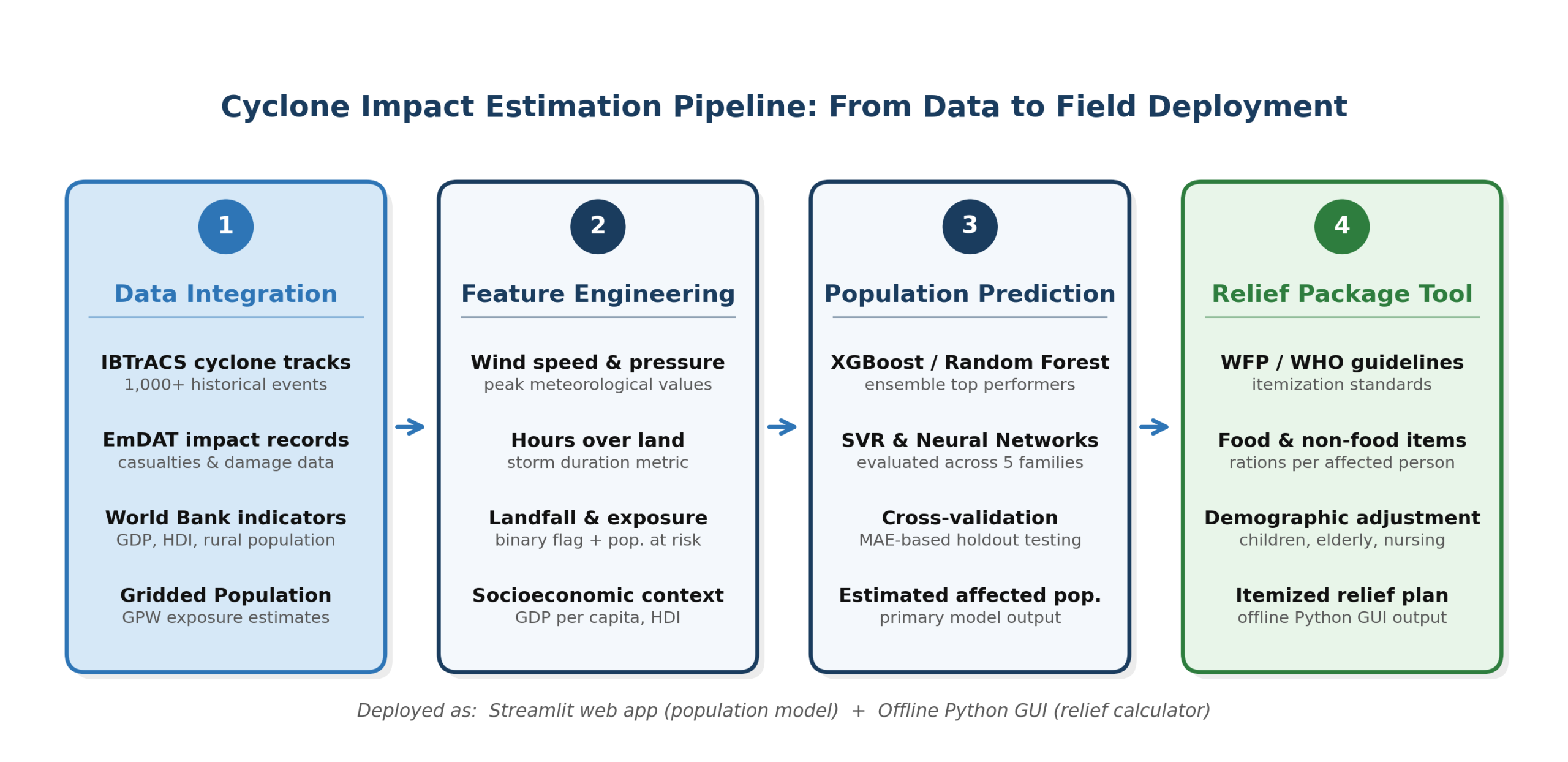
Figure 1: Cyclone Impact Estimation Pipeline: from data integration to field deployment
Phase 1: Data Collection and Integration
Five datasets were integrated: IBTrACS cyclone tracks, EmDAT disaster impacts, World Bank socioeconomic indicators, Gridded Population of the World, and WFP/WHO relief standards. Missing data was collected manually or scraped from cyclone reports across multiple ocean basins.
Phase 2: Feature Engineering and Population Prediction Modeling
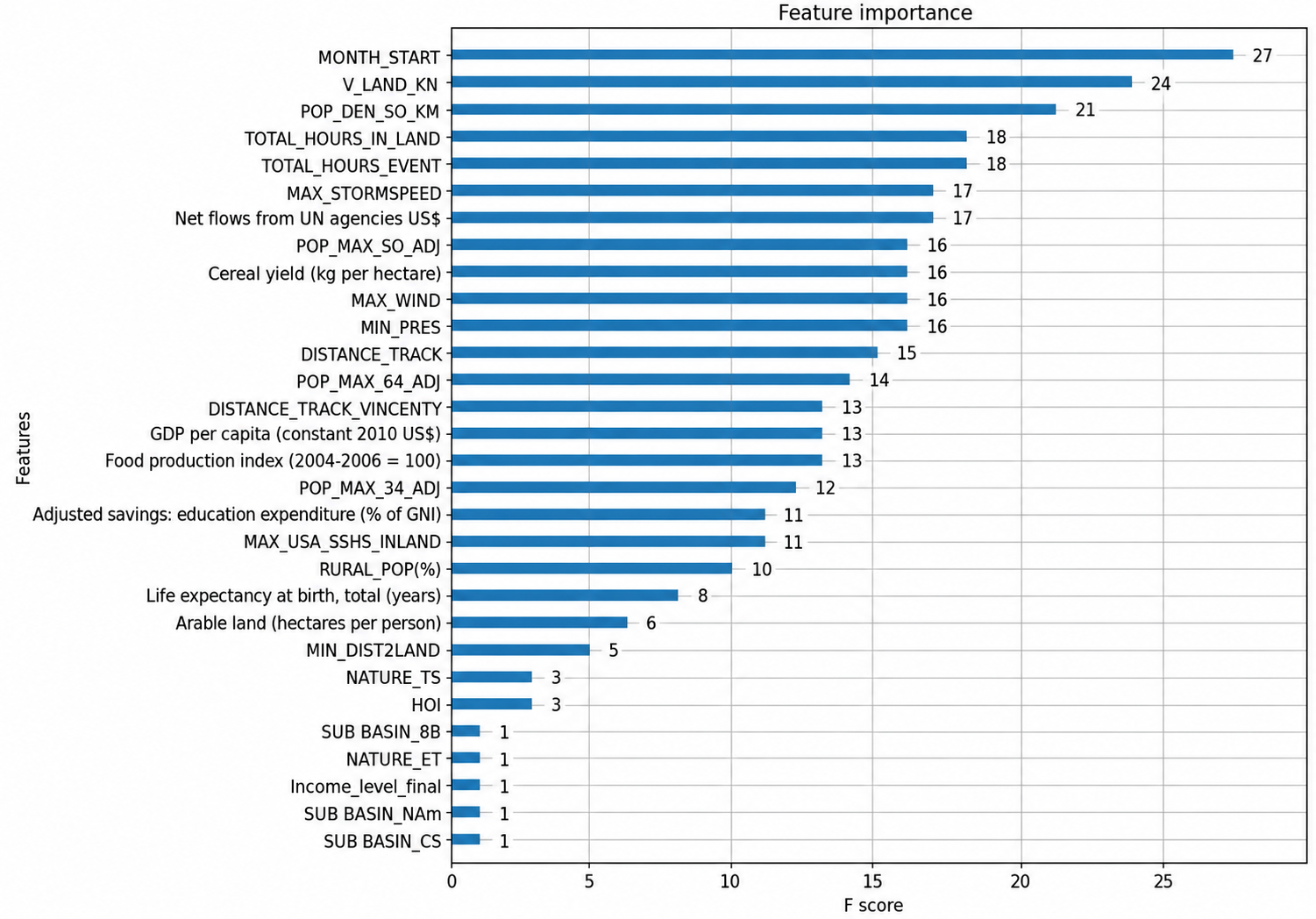
Feature engineering combined two categories of variables. Meteorological inputs included maximum wind speed, minimum atmospheric pressure, total hours over land, landfall status, and maximum storm speed. Socioeconomic inputs included exposed population, GDP per capita, rural population share, Human Opportunity Index (HOI), and historical total damage and deaths.
Six algorithm families were evaluated: Random Forest Regressor, Gradient Boosted Trees, XGBoost, Support Vector Regression, Neural Networks, and ensemble combinations. Models were assessed using mean absolute error and holdout testing; XGBoost emerged as the strongest single model, with performance highest for moderate-scale events where historical training data is most abundant.
Figure 2: Most influential features for affected-population modeling
Phase 3: Relief Package Calculation
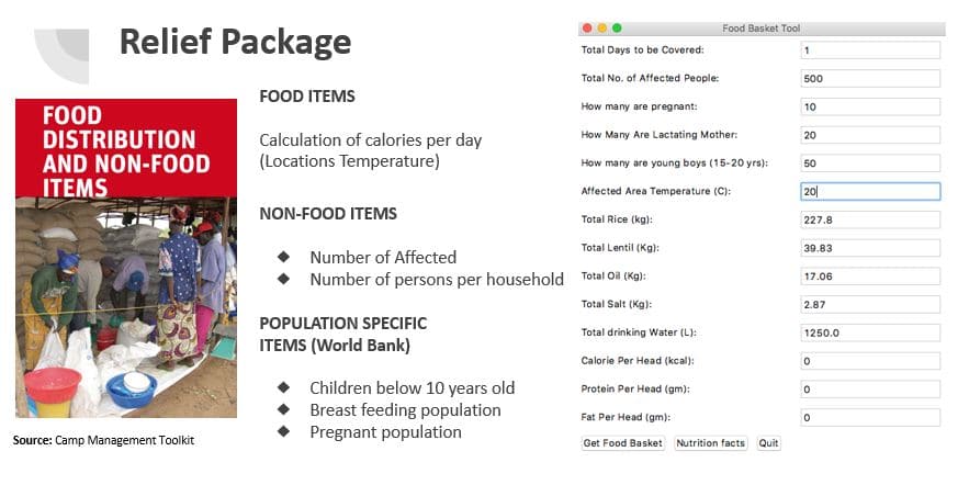
A mathematical conversion layer applied WFP and WHO nutritional standards to calculate food rations, drinking water, and non-food items (blankets, hygiene kits, shelter materials), adjusted for demographic groups including pregnant women, lactating mothers, and children. Inputs included affected population count, days of coverage, and area temperature. The output was a complete itemized relief plan, runnable locally without connectivity.
Phase 4: Field Deployment Architecture
The population prediction model was deployed as a Streamlit web application, intentionally minimal to function under low-bandwidth conditions. Field users enter standard cyclone forecast parameters and receive an estimated affected population within seconds, without requiring a data science background.
That estimate feeds into a separate offline Python GUI that runs the relief calculation locally, drawing on pre-loaded WFP nutritional standards and demographic lookup tables. Isolating the calculation from network connectivity means the itemized relief plan is always available when it is needed most.
What Was Delivered: Two Linked Field Tools
The 8-week build produced two tools designed to work in sequence: a web-based population estimator and an offline relief calculator. Together they cover the full workflow from cyclone forecast to itemized logistics plan, each addressing the phase of the operation where it is most critical.
Figure 3: Relief package calculator: inputs and itemized output
Population prediction web app: A Streamlit application that accepts cyclone forecast parameters and returns an estimated affected population. Designed for low-bandwidth conditions; results are generated in seconds from a standard forecast.
Offline relief package calculator: A Python GUI that translates a population estimate into a complete itemized relief plan: food rations, non-food items, and shelter requirements, adjusted for household demographics and duration of coverage. Runs locally without internet access.
Open-source codebase and documentation: All models, feature engineering pipelines, and assumptions were documented and published. Any humanitarian organization can inspect, reproduce, or adapt the system for their own operational context.
Impact: What WFP Field Teams Could Do That They Could Not Before
Before this system, generating a relief estimate required a field assessment, which meant waiting for roads to open, communications to restore, and experts to reach affected areas directly. That process could take days. The two-tool system can reduce the time from cyclone forecast to itemized relief plan from hours to minutes, using forecast data alone.
A WFP planner facing an approaching cyclone can enter forecast parameters into the Streamlit interface, receive a population estimate, and run multiple relief scenarios using different forecast assumptions to support logistics pre-positioning. The entire process takes minutes, not hours.
The architecture is not cyclone-specific. Any sudden-onset hazard with a geospatial exposure signature — earthquakes, tsunamis, large-scale floods — can use the same pipeline once appropriate training data is assembled, making the prototype a foundation rather than a one-use tool.
Benefits for Clients: Speed, Accessibility, and an Open Codebase
Data-driven relief planning instrument: The system gives humanitarian planners a defensible, quantitative estimate of affected populations within minutes of a forecast update, replacing or supplementing expert judgment with a reproducible, auditable calculation grounded in 1,000+ historical events.
No specialist ML expertise required to use: Both tools were designed for field planners, not data scientists. The Streamlit interface requires only standard cyclone forecast parameters. The offline GUI produces ready-to-use output tables. No model tuning or programming knowledge is needed to run either.
Open-source via OmdenaLore: The full pipeline, including data integration, feature engineering, model code, and relief calculation logic, is available through OmdenaLore, Omdena’s open-source knowledge-sharing platform. Any government emergency management office or humanitarian organization can audit, fork, and adapt the system at no cost.
What Building a Cyclone Relief Estimation System for WFP Taught Us
Seventy percent of the build was data: clean data matters more than sophisticated algorithms
More than 70% of the project’s 8-week timeline was spent on data collection, digitization, and cleaning. The modeling itself was relatively fast once the dataset was ready — the bottleneck was not the algorithm. Future disaster response projects should invest heavily in data infrastructure before any modeling begins.
Offline-first design from day one produces a system that works when it is needed most
Designing the system as two components (a web app for prediction and an offline GUI for calculation) was a decision made early because field connectivity after a cyclone is unreliable. Bolting offline capability onto a cloud-first system would have been harder and less reliable. Deployment constraints belong in the design brief, not the integration phase.
A model that works well on moderate events is still operationally useful: do not wait for perfection
The model performs strongly for events affecting up to 150,000 people, which covers the majority of historical cyclone impacts. For catastrophic events, accuracy decreases due to sparse training data. The team documented this clearly rather than overfitting to extreme cases. A tool honest about its limits is more operationally useful than one claiming coverage it cannot deliver.
What’s Next
Expanded training data for large-scale events: Targeted collection and digitization of historical records for catastrophic cyclones (events affecting more than 500,000 people) would materially improve model performance at the high end of the scale.
Real-time satellite damage proxies: Integrating near-real-time satellite-derived damage indicators (building collapse estimates, flood extent maps) as additional model inputs would allow estimates to be updated as a storm progresses, not just at landfall.
Key Achievements
A Socioeconomic-Meteorological Model Built Around Operational Reality
The model’s distinguishing characteristic is not its algorithm but its feature set. By combining GDP per capita, Human Opportunity Index, rural population share, and landfall status with meteorological variables, the system captures why the same storm produces different outcomes in different countries — a framing grounded in WFP’s field experience that makes estimates operationally meaningful.
A Two-Component Architecture Designed for Field Conditions
Splitting the system into a web app for prediction and an offline GUI for calculation reflects a core constraint of post-disaster operations: connectivity cannot be assumed. The architecture is replicable: any humanitarian agency can adopt the same two-component pattern for their own deployment context.
An Open Baseline for Humanitarian Impact Estimation
Publishing the full pipeline gives the humanitarian community a documented, replicable starting point for machine learning-based impact estimation, something the sector lacked before this project. Any agency can fork the codebase, retrain on their own historical data, and adapt the feature set to a different hazard type without building from scratch.
About the Project
Omdena partnered with the WFP Innovation Accelerator in to build a machine learning-based disaster relief estimation system. A 34-person team from 19 countries delivered a population impact prediction model and an offline-capable relief package calculator in 8 weeks. The full pipeline is open-source and extensible to disaster types beyond cyclones.
FAQ
How is AI helping in disaster response during cyclones?
AI analyzes cyclone data and population vulnerability to estimate affected areas and support faster, more accurate relief planning.
How does AI improve humanitarian decision-making?
AI provides early impact predictions, enabling responders to prioritize locations, allocate resources efficiently, and act before full assessments are available.
What datasets are used to train AI disaster response models?
Models use cyclone tracks, wind speed, pressure, population density, socioeconomic indicators, and historical disaster impact data.
Does AI replace field assessments in disaster response?
No. AI supports—rather than replaces—human assessment by providing early estimates that guide initial planning and resource mobilization.
How does AI help determine what relief items are needed?
Predicted population impact is converted into food and non-food item requirements based on WHO and WFP guidelines, household size, and vulnerable groups.
Can the AI system be used for disasters other than cyclones?
Yes. The same approach can be applied to earthquakes, floods, tsunamis, and other sudden-onset disasters with geospatial exposure.
How accurate are AI-based cyclone impact predictions?
Accuracy is strongest for moderate-scale events. As more impact data is collected over time, AI models continue to improve through retraining.
Can AI predict how many people will be affected by a cyclone?
Yes. Machine learning models can estimate affected populations by combining storm data with demographic and socioeconomic indicators.
Continue with Omdena
Share this article
Share on LinkedIn, send by email, or copy the direct link.