AI-Driven School Mapping: Enhancing Educational Planning in Sudan

Background
Accurate school location data is critical to bridging the global digital divide. Giga, a joint initiative by UNICEF and ITU, aims to connect unconnected schools worldwide to the internet, empowering children with access to online learning opportunities. However, in many regions, such as Sudan, school location records are incomplete, inaccurate, or non-existent. Traditional mapping methods are costly, labor-intensive, and challenging to implement in remote or insecure areas.
To address this issue, Giga partnered with Omdena to develop an innovative AI model capable of identifying school locations in Sudan using high-resolution satellite imagery.
Objective
The primary goal of this project was to:
- Develop an accurate Deep Learning model to identify and map school locations across Sudan using satellite imagery.
- Enable cost-effective and scalable solutions for school connectivity planning.
- Support the government and UNICEF in improving education accessibility by addressing gaps in school infrastructure and internet connectivity.
Approach
Omdena conducted a six-week collaborative challenge with 52 global participants. The project utilized a combination of advanced AI techniques, high-resolution satellite images, and existing school location data.
- Data Collection:
- Geo-diverse, high-resolution satellite images of Sudan.
- Limited school location datasets provided by UNICEF’s Sudan Country Office.
- Model Development:
- Training Deep Learning algorithms to distinguish schools from other structures.
- Fine-tuning the model using real-world contextual parameters provided by local experts.
- Validation and Accuracy:
- The model achieved 95% accuracy in identifying schools and delineating their boundaries, a benchmark for AI-based mapping solutions.

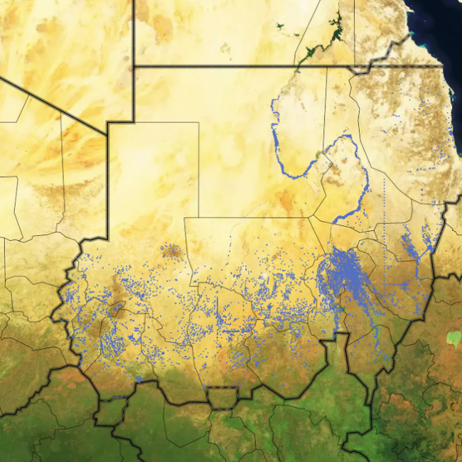
The map of Sudan on the Project Connect platform
shows the schools (blue dots) where data is currently available
Results and Impact
The AI-driven school mapping initiative produced transformative results:
- High Accuracy: The model identified school locations with 95% precision, significantly reducing the reliance on traditional mapping methods.
- Improved Planning: Enabled the identification of schools in previously unmapped or remote areas, providing actionable insights for infrastructure development.
- Enhanced Education Accessibility: Mapping efforts are vital to improving connectivity levels and addressing challenges such as a lack of teaching materials, inadequate facilities, and the high number of out-of-school children in Sudan.
- Scalability: The AI model provides a scalable solution for other regions with similar challenges.
These outcomes will empower policymakers and educational stakeholders to allocate resources effectively, bridging the digital divide in Sudan.
Future Implications
The next phase involves scaling the AI model across the entirety of Sudan to uncover additional unknown school locations. This expansion will:
- Assist the government in resource allocation and internet infrastructure planning.
- Provide critical data to assess existing connectivity reliability.
- Influence global efforts to leverage AI for sustainable development goals (SDGs) in education.
By transforming school mapping processes, this initiative underscores the potential of AI-driven solutions to revolutionize educational planning, contribute to environmental sustainability through efficient resource use, and advance the mission of universal internet access for every child.
The challenge has been hosted by our friends at Giga, a joint initiative of UNICEF and ITU


Become an Omdena Collaborator

